Healthy Food Map for South L.A.
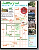
Welcome to the Healthy Food Map for South L.A. — which seeks to provide residents and the community with a guide to healthy food and living! The Healthy Food map is the second in RideSouthLA’s map series, which began with the Watts Ride map.
 Status: We launched the map at a safe routes ride on March 3, 2013. The launch celebrated six months of community work with bicycles, mapping walks and digital tools to create and develop this new print map, and now distribution will take place both online and in print. Do you have ideas for who might link to it, or hand out print copies? Let us know!
Our goal with this map is to show that healthy eating and living is possible in South L.A. First we emphasize buying healthy food locally, and then healthy activities like bike rides and gardening. Yet our map is also a tool for social change — it argues for the future of South Los Angeles, and how our community can grow while deepening our distinctive culture.
- “My hope is that this map will allow us to bring to light some of the many efforts to address food access in South Los Angeles,” says Tafarai Bayne of T.R.U.S.T. South LA. “Both visitors and residents can use the map to find all kinds of local resources, some obvious and some not so. This map helps go beyond what’s not working, to reveal positive stories about South Los Angeles.”
- A second partner organization,
 Community Services Unlimited (CSU), is primarily focused on food, health and sustainable communities. “This map is an amazing tool for accessing the innovative efforts that have emerged from within South LA to counteract the overwhelmingly bleak reality of our food environment,” said Neelam Sharma, CSU’s Executive Director. “It builds on what folks like CSU have been working on for decades and is an inspiration for what any of us can do when we decide to make change.”
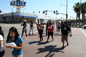
 The making of this map was an exciting adventure. Along with a large group of teenagers from schools from South L.A., we walked (and some rode their bikes) through the streets of the neighborhood, discovering and documenting healthy places to eat. The participants then uploaded their photos directly to our website and pinpointed the location. Funding for the project also came from USC’s Neighborhood Outreach program.
- This research approach seeks to identify community and communication assets, drawing on the Communication Infrastructure Theory of the USC Metamorphosis project. We believe that knowledge about the neighborhood is most authentic and powerful when it comes from the community, so we invited participants to use their ordinary camera mobile phones for the mapping and pictures — avoiding the need for smart phones.
- Our amazing graphic designer Colleen Corcoran turned the pictures and data into a powerful and user-friendly visual. Most importantly, to validate the map over several months we brought successive versions to youth meetings, and even CicLAvia.
- Related links:
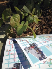
 We previewed this map at a Gardening Workshop with the Garden Gateway Project on January 12th 2013 at the CSU Urban Farm (see image at right).
Anyone can download the Healthy Food print map for free. There is also a hi-resolution version (1.4mb) of the map.
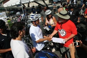
 Distribution for the map is ongoing. At left is Los Angeles Mayor Antonio Villaraigosa (in helmet) shaking hands with USC Prof. François Bar and discussing the healthy food map during CicLAvia this past fall. The logo on the shirt is the East Side Riders, a core partner for RideSouthLA.
Our video of the ride has some great comments and footage. See also our zipcode map of where people came from for the ride.
Press hits include:
- 2013-03-04: LA Streetsblog LA: Do You Know Where to Find Healthy Food in South L.A.? RideSouthLA and CSU Take Riders on a Different Kind of Food Tour
- 2013-03-03: NBC Los Angeles on 6pm news: Group Hopes to Drop South LA’s High Obesity Rate by Michelle Valles
- 2013-02-28: KPCC’s OnCentral: Tour healthy food stops in South LA with weekend bike ride
- 2013-02-28: USC News on “Cycling Toward Health” (echoing a story from USC Annenberg news on our bike parade)
- 2013-02-27: LAist on “New Food Maps Program Aims to Encourage Healthy Lifestyles in South L.A.” by Krista Simmons
- 2013-01–Epicurious on Mapping Healthy Food in an L.A. ‘Desert’ by Joanne Camas
- 2012-09-14: StreetsBlog LA on how the Healthy Food Walk Around USC Neighborhood Unearths Tensions Between the University and the Community — some great critiques!
- …see also our complete press coverage page.
About us: More information is on the about page and below.
Ride South LA ( http://RideSouthLA.com ) is a coalition of organizations bringing bicycling, mobile mapping and social justice to South LA. Many of our partner organizations are listed below.
T.R.U.S.T. South LA, was established in 2005 as a permanent and democratic steward of land in South Los Angeles that works toward community- focused development. Recently they have partnered with CicLAvia and a number of community stakeholders to bring CicLAvia to South LA and now work towards the expansion of safe biking and pedestrian facilities. Read more about their efforts http://trustsouthla.org.
Community Services Unlimited Inc. (CSU), is a 501c3 established in 1977 and headquartered in South Central Los Angeles. Since then it has created community programs and organizing campaigns like the early Safe Seniors to the more recent Free Medical Screening Program and the most recent From the Ground Up. CSU’s mission is to foster the creation of communities actively working to address the inequalities and systemic barriers that make sustainable communities and self-reliant life-styles unattainable. Read more about CSU at http://www.csuinc.org/
The Mobile Urban Mapping Project within the USC Annenberg School for Communication and Journalism is a joint effort of two research groups, and is responsible for our ParTour methodology for crowd-sourced mapping and engagement. Our parent research groups include the Metamorphosis Project led by Prof. Sandra Ball-Rokeach, and the Mobile Lab led by Prof. François Bar. The ParTour project is supported in part by the Annenberg Innovation Lab. For more on the theory behind this work, see our description of situated engagement, or the recently-launched MetaConnects.org, which is a translation of Metamorphosis methods into everyday use for community organizations.
The Laboratory on the Social Frontier (LOSF) advances scholarly participatory research and applies it in practical strategies that foster civic engagement and enable communities to represent themselves. LOSF brings together communication research and journalism and strengthens links between academics and practitioners. LOSF encourages interdisciplinary collaboration within the Annenberg School, across USC and with the vibrant communities that make up Los Angeles. LOSF is also a vehicle for providing USC students with rich opportunities to engage with those communities.

