Below are a few reflections from Otto Khera of the RideSouthLA team, who joined the ride. For an extended discussion, see coverage of the ride from Sahra Sulaiman. The ride was part of the Neighborhood Bike Ambassadors Program – South LA organized by the Los Angeles County Bicycle Coalition.
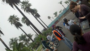
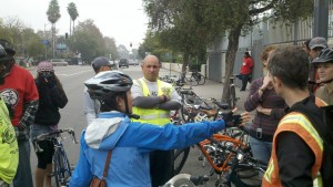
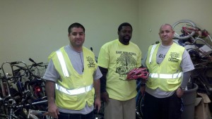
On Saturday, December 8, 2012 a committed team of Los Angeles City planners led by David Somers together with cyclist mover and shaker and Streets Blog LA South LA beat columnist Sahra Sulaiman set off on bicycles to Watts from downtown LA in the early morning. The goal: To understand and document the most pressing cycling and walking infrastructure needs in the Watts area based on the local feedback from expert cyclists from the area.
Read the rest of this entry »
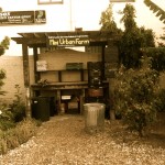
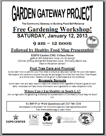
Save the date everyone! We will be previewing our first healthy food map on Saturday, January 12th, 2013 in Los Angeles. We want your feedback. Our demo will happen alongside a Garden Gateway workshop and tree giveaway from our partner CSU.
See the flyer below for details on CSU’s event. We will demo the map toward the end of the free gardening workshop from 9am-12noon, and probably a bit after 11am at the EXPO Center/CSU Urban Farm, 3980 S. Bill Robertson Lane. LA, CA 90037 (Corner of King Blvd & Bill Robertson Lane. Formerly Menlo Ave. Next to the senior center).
Here’s the event flyer:
If you want to know more about our upcoming events and community projects, sign up for our newsletter.


UPDATE: after the walk, Nicola Twilley assembled a wonderful picture gallery and map of pictures.
Today we are working with Foodprint LA on a walking tour that will provide “an inside look at downtown LA’s cold storage infrastructure, caffeine artisans, and future food market, followed by a food map presentation over happy hour drinks. The walking tour will take place from 1pm to 5pm on Saturday, December 8, and the party will follow on immediately afterward, from 5 to 7pm.”
Starting points during the walk: live picture stream (showing those tagged ‘foodwalk’); and live map of food stories downtown.
For more information:
- Our related project to produce a South LA healthy food map in a participatory fashion.
- About the philosophy and technology behind this innovation called ParTour
- About Ride South LA, our host project which seeks to connect physical activity with community development and health.
Last Sunday, on November 4th a group of enthusiastic cyclists and walkers gathered together at Mercado de Paloma to be guided by the RideSouth LA coalition to explore South LA on safe bike and walk routes that investigate the healthy food options around the area. As opposed to our last walk and ride, cyclists tremendously outnumbered the walkers. With around 30 participants on bikes and a cadre of 5 walkers – both groups were ready to enjoy a explore what healthy food in South LA looks like.

The walkers set off with the primary purpose to examine the differences between two major supermarkets in the area – Fresh & Easy and El Superior. These two markets are very different in terms of size, food offerings and customer base. Fresh & Easy is much smaller and targets on-the-go students with many ready-to-eat meals in their food selection (see picture). El Superior on the other hand is a much larger store with many more options and catered to many of the Latino families in the neighborhood.

Read the rest of this entry »
On the Sunday morning of October 7th thousands of cyclists and walkers came out to South LA to enjoy a great day out at CicLAvia. Major roads intersecting downtown LA were closed for the day, making it safe for people to ride or walk through the neighborhood with lots of entertainment along the way.
Our team with RideSouthLA seized this day to distribute our latest map (see our pictures), showing people exactly where they could find healthy food around the South LA area. Our healthy food map, which is available for download in draft form, also shows what routes are and unsafe to use to get to these destinations. We made the map based on data collected with a group of teenagers from local middle and high schools, who walked and cycled through the community and took pictures of healthy food places encountered along the way.
What did people think? On the day of CicLAvia, we handed out over 300 maps. Everyone was very engaged and we managed to collect feedback from 85 respondents from 60 different ZIP codes. The map below shows which parts of Los Angeles our respondents come from:

The overall common trends that were identified from the responses are that:
Read the rest of this entry »
Hey everyone! If you don’t have plans on October 24th yet, please join us at MCM’s 3rd Annual Bicycle Awards. Tickets to the fundraiser, where we will be supporting low income cyclists, cost $45. The ticket includes a full dinner, live/silent actions and tons of fun entertainment on the night!
We would be excited to see you there. The event will take place at La Fonda Supper Club. Click here for the full address, ticket purchases and more information.
We hope you can make it – the more the merrier!
Join the Black & Brown Unity Ride on Sunday October 21st 2012! We will start off in Boyle Heights and finish at the Watts Labor Community Auction Center.
Show your support and join us for this lovely Sunday outing!

Yesterday on October 7th was the 5th CicLAvia and our team was in force. We handed out drafts of our new healthy food map, and asked people what they thought. Do you have ideas on what else should be on the map? Let us know! Here are a few pictures from the day…
We setup underneath this plane with a booth to hand out the maps:

Mayor Antonio Villaraigosa (wearing a helmet) stopped by, and USC’s François Bar (in red shirt) told him more about the map:

Sandra McNeill of TRUST South LA was handing out maps, and asking passersby for their ideas. Also, we gathered email addresses of those who wanted to hear more about our upcoming walk in November of healthy food spots:

Dana Chinn of USC with students Jeff Tamaru (business) and Richelle Gribble (fine arts/social entrepreneurship) — note also the apples from CSU in the foreground!

George Villanueva of USC in full force, surveying participants about the map:

A girl bikes by a stack of folded maps — I wonder, in 10 years what will healthy food look like in South LA?

Have more pics about the release of this map? Let us know!
On September 9th we will be hosting an exploration of healthy food options focusing on the area immediately surrounding the newly built Expo Line train near the University of Southern California.
We will be exploring Safe Routes and Healthy Food resources on a nice sunday afternoon in South Los Angeles.
Route focuses on: King Blvd, Vernon ave, Western Blvd and Adams Blvd.
Event will consist of your choice of a neighborhood Walk or Bike Ride.
Please bring your own bike. 🙂
Event is all ages.
Meet up Location:
3655 S Grand Ave Ste 240, Los Angeles, CA
Event Start Time: 10:00am
Event End Time: 1:00pm
This post will have unfolding details for the upcoming CicLAvia Southeast Exploratory Ride on August 26th.